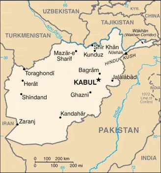
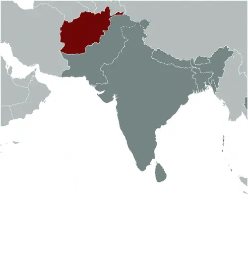
Google Maps and Detailed Facts of Afghanistan (AF). This page lets you explore Afghanistan and its border countries (Country Location: Southern Asia, north and west of Pakistan, east of Iran) through detailed Satellite imagery – fast and easy as never before Google Maps.
Find comprehensive information about this country’s diversity below: Google Maps, geography, economy, science, people, culture, environment, government, and history – All in One Wiki page.
There is also a Street View and free Driving Directions at your service. Your Google Satellite Map Sightseeing in Afghanistan, in Asia, starts here at Driving Directions and Maps.com.
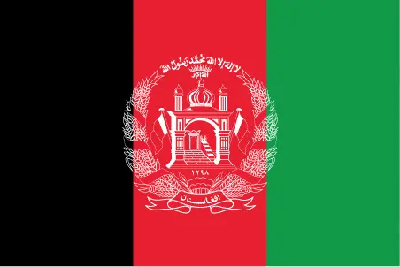
| Borderline map of Afghanistan | Location map of Afghanistan | Flag of Afghanistan |
|---|---|---|
 |  |  |
Table of contents
- Background
- Overview
- Google Maps
- Climate
- Geography
- Resources and Land Use
- Population Data
- Economic Data
- Drinking Water Source
- Population, Median Age, Migration, and Citizenship
- Average Number of Childbirths
- Is this country a Safe Destination?
- Healthcare and Infectious Diseases
- Natural Hazards
- The Flag and Other Symbols
- Constitution
- Legal System
- About the Unemployment Rate, Labor Force, and Poverty Line
- About the Budget and Central Government Debt
- Inflation Rate and Prime Lending Rate
- Export/Import Partners and Data
- Renewable Energies Used
- Telecommunication Data, Calling Code
- Transport Infrastructure
- More Interesting Facts
Background
Afghanistan’s history is marked by its strategic location along the Silk Road, connecting cultures and trade. Established as a nation in 1747 by Ahmad Shah Durrani, it became a battleground for British and Russian Empires during the 19th century. The 20th century saw a tumultuous period with coups and Soviet invasions, leading to long-standing conflicts. The Taliban’s rise to power, U.S.-led intervention following 9/11, and the eventual withdrawal of international forces in 2021 shaped its recent history, leaving the country under Taliban control.
Overview
Afghanistan, a landlocked South Asian country, grapples with ongoing political, social, and economic challenges. Despite its rich cultural heritage and natural resources, it remains one of the world’s poorest countries, deeply affected by decades of conflict. The Taliban’s control has led to international isolation, further impacting its development.
Official Name: Islamic Republic of Afghanistan
Date of Formation: The modern state of Afghanistan was established on April 27, 1978, but its historical formation as a distinct political entity dates back to 1747 under Ahmad Shah Durrani.
Capital: Kabul
Population: Over 39 million (as of 2023)
Total Area: 252,072 square miles / 652,864 square kilometers
Population Density: Approximately 60.4 per square mile / 23.3 per square kilometer
Languages: Pashto and Dari (Persian) are the official languages. Other languages include Uzbek, Turkmen, Balochi, Pashai, Nuristani, and Pamiri.
Religions: Predominantly Islam (Sunni and Shia)
Ethnic Origin: The major ethnic groups are Pashtun, Tajik, Hazara, and Uzbek. There are also smaller groups like Turkmen, Baloch, and others.
Government: Islamic Emirate (under Taliban control as of the latest information in 2023)
Currency: Afghan Afghani (AFN)
Literacy Rate: Approximately 43% (latest available data may vary)
Calorie Consumption: Not specifically available, Afghanistan faces significant food security challenges, with many regions not meeting adequate calorie intake requirements.
Google Maps Afghanistan
About 75% of this landlocked Asian country is inaccessible. Predominantly mountainous. The highest range is the Hindu Kush. Fertile plains border mountains. Desert plateau in the south.
The map below shows Afghanistan’s cities, towns, highways, main roads, streets, and Street Views. To find a location, use the form below, type any city or place, view a simple map, and click the “show map” button.
Using Google Maps, one can explore Afghanistan’s rugged terrain and historical sites. It offers a window into the diverse landscapes, from the Hindu Kush mountains to the bustling streets of Kabul. Google Maps also highlights the challenges in infrastructure and connectivity in this war-torn country.
Climate
Afghanistan’s climate, predominantly arid to semiarid, is marked by stark contrasts in temperature and precipitation, which significantly impact the country’s agriculture, living conditions, and overall socio-economic stability. Here’s an extended overview of Afghanistan’s climatic conditions, including some interesting and factual aspects:
- Temperature Extremes: The country experiences extreme temperature variations. In the mountainous regions, winter temperatures can plummet to below -25°C (-13°F), while in the summer, temperatures in the lowland areas can soar above 35°C (95°F). In some desert areas, summer temperatures can even reach 50°C (122°F).
- Precipitation Patterns: Afghanistan’s annual precipitation varies greatly by region. The mountainous areas, particularly in the northeast, receive the most precipitation, often in the form of snow, with some regions getting up to 1,000 mm (39 inches) annually. In contrast, the southwestern lowlands are extremely dry, receiving less than 300 mm (12 inches) of rain annually.
- Snowfall and Water Resources: The Hindu Kush mountains receive significant snowfall, which is crucial as it feeds the major river systems. The melting snow in spring and summer provides much-needed water for irrigation in the agricultural plains. However, rapid snowmelt can also lead to destructive spring floods.
- Droughts and Desertification: Afghanistan frequently experiences droughts, particularly in the southern and western regions. These droughts have become more severe and prolonged in recent years, possibly due to climate change. This has led to increased desertification, adversely affecting agriculture and leading to water shortages.
- Impact on Agriculture: The extreme climate poses challenges for agriculture, which is a key livelihood for a large portion of the population. The short rainy season and long, dry summers require efficient irrigation systems to support farming. The local climate often dictates crop choices, with hardy crops like wheat being predominant.
- Regional Climatic Variations: There are significant regional climatic variations within the country. The central highlands experience a subarctic climate with very cold winters, while the lowlands of the Sistan Basin have a desert climate with scorching summers. The eastern monsoon rains influence the climate in the northeast, bringing more precipitation to that region.
- Environmental Challenges: The harsh climate exacerbates environmental issues such as soil erosion, deforestation, and biodiversity loss. These environmental challenges are compounded by overgrazing, unregulated land use, and ongoing conflict, which hinders effective environmental management.
- Climate Change Impacts: Afghanistan is particularly vulnerable to the impacts of climate change. Increasing temperatures, changing precipitation patterns, and more frequent extreme weather events, like droughts and floods, are likely to intensify existing challenges related to water scarcity, food security, and disaster management.
- Urban Heat Islands: In urban areas like Kabul, the phenomenon of urban heat islands is observed, where temperatures are significantly higher than in surrounding rural areas. This is due to the high concentration of buildings, vehicles, and human activity, combined with limited green spaces.
- Traditional Coping Mechanisms: Afghan communities have historically adapted to their harsh climate through various means. These include architectural designs like thick mud walls for insulation, underground irrigation canals (karez) to conserve water, and seasonal migrations (transhumance) among pastoral communities.
The climate of Afghanistan, with its extremes and variability, plays a critical role in shaping the lives of its people, their livelihoods, and the country’s overall stability. Understanding and adapting to these climatic conditions is crucial for sustainable development and resilience in Afghanistan.
Geography
Afghanistan’s geography is indeed characterized by the Hindu Kush mountain range, which not only forms a significant natural barrier but also creates distinct climatic and cultural regions within the country. Here’s an extended look at Afghanistan’s geographical features, including more detailed statistics and information about its neighboring countries:
- Hindu Kush Mountains: This formidable mountain range stretches across central Afghanistan, with peaks rising to over 7,000 meters (23,000 feet). The highest point in Afghanistan, Noshaq Peak, stands at 7,492 meters (24,580 feet) and is located in the Hindu Kush. These mountains are crucial in influencing local weather patterns and source several rivers.
- Topography and Land Use: Afghanistan’s landscape is predominantly mountainous, with plains in the north and southwest. About 75% of the land is mountainous or semi-mountainous, while only about 12% is arable. The arable land is primarily found in the northern plains near the Amu Darya River and some valleys within the Hindu Kush.
- Climate: The country experiences a continental climate with hot summers and cold winters. Precipitation varies significantly across regions, with the mountainous areas receiving more rainfall and snow. The lowland regions, particularly in the southwest, are arid and desert-like.
- Surrounding Countries:
- Pakistan: To the east and south, Afghanistan shares a long and porous border with Pakistan, extending approximately 2,670 kilometers (1,660 miles). This border, known as the Durand Line, traverses a variety of terrains, including mountainous regions and tribal areas.
- Iran: To the west, Afghanistan’s border with Iran stretches about 921 kilometers (572 miles). This boundary is marked by a contrasting landscape, including deserts and mountain ranges.
- Tajikistan lies to the north, across the narrow Wakhan Corridor. The border is about 1,357 kilometers (843 miles) long and is predominantly mountainous, following the Pamir Mountains.
- Turkmenistan: Also to the north, Afghanistan shares an 804-kilometer (500-mile) border with Turkmenistan. The flat, arid terrain of the Karakum Desert mainly characterizes this boundary.
- Uzbekistan: To the north, Afghanistan has a shorter border with Uzbekistan, approximately 144 kilometers (89 miles) in length. The Amu Darya River forms a natural border between the two countries in this region.
- China: Afghanistan has a small border with China to the northeast, extending only about 76 kilometers (47 miles). This border is at the end of the narrow Wakhan Corridor, a mountainous region serving as a strategic buffer zone.
- Rivers and Water Resources: Major rivers include the Amu Darya, the Helmand, and the Kabul River. These rivers are crucial for irrigation, which is vital for agriculture in this predominantly arid country. However, water management remains challenging due to varying seasonal flows and regional disputes over water rights.
- Natural Resources: Afghanistan is rich in natural resources, including significant deposits of minerals like iron ore, copper, gold, and rare earth elements. The country also has untapped reserves of natural gas and petroleum, although ongoing conflicts and challenging terrain have limited their exploration and exploitation.
This diverse and complex geography significantly influences Afghanistan’s climate, culture, and socio-economic dynamics while also shaping its relationships with neighboring countries.
Resources and Land Use
Rich in natural resources like natural gas, petroleum, and precious stones, Afghanistan’s economic potential is significant. However, ongoing conflict and lack of infrastructure hamper resource exploitation. Agriculture remains a primary livelihood, with 58.1% of land used for farming.
Population Data
Afghanistan’s population, estimated at over 39 million in 2023, faces challenges like high birth rates and a young median age. Ethnic diversity is vast, with Pashtuns, Tajiks, Hazaras, and Uzbeks being prominent groups.
Economic Data
The Afghan economy, heavily reliant on agriculture and foreign aid, faces severe challenges like high unemployment and inflation. The Taliban’s takeover has led to a decrease in international support, exacerbating economic instability.
Drinking Water Source
Access to clean drinking water is limited, with only 76.5% of the population having access to improved water sources. The disparity in water access between urban and rural areas reflects broader infrastructural challenges.
Population, Median Age, Migration, and Citizenship
Afghanistan’s young population, with a median age of 19.5 years, faces issues like migration due to conflict and economic hardships. The country’s citizenship laws are based on descent, and there’s significant internal displacement.
Average Number of Childbirths
The average number of childbirths per woman stands at 4.53, indicative of high fertility rates. This contributes to the rapidly growing population and challenges healthcare and education systems.
Is this country a Safe Destination?
Travel to Afghanistan is advised against due to ongoing conflict, terrorism, and political instability. Safety concerns are paramount, with risks of violence and kidnapping.
Healthcare and Infectious Diseases
Healthcare infrastructure is inadequate, with low physician and hospital bed density. Infectious diseases are a significant concern, and the country continues to battle polio.
Natural Hazards
Afghanistan is prone to natural hazards like earthquakes, especially in the Hindu Kush region, along with flooding and droughts, exacerbating humanitarian challenges.
The Flag and Other Symbols
The national flag, with its black, red, and green vertical bands, symbolizes Afghanistan’s past, bloodshed for independence, and hope or prosperity. Other symbols, like the lion, reflect the nation’s identity.
Constitution
The 2004 constitution, suspended following the Taliban’s takeover, represented a brief period of democratic governance. The current regime enforces its interpretation of Islamic law.
Legal System
Afghanistan’s legal system has shifted from a mix of civil, customary, and Islamic law to a theocratic system under Taliban rule, focusing on Sharia law.
About the Unemployment Rate, Labor Force, and Poverty Line
Unemployment and poverty are significant challenges. The unemployment rate hovers around 13.28%, and over half of the population lives below the poverty line.
About the Budget and Central Government Debt
Limited revenues and high dependence on international aid constrain the country’s budget. The public debt is relatively low but is overshadowed by economic instability.
Inflation Rate and Prime Lending Rate
Inflation remains a concern, affecting the affordability of necessities. The lending rate is not well-defined due to the informal nature of much of Afghanistan’s economy.
Export/Import Partners and Data
Afghanistan’s exports include gold and agricultural products, primarily to the UAE, Pakistan, and India. Imports include essential items like wheat flour and petroleum, reflecting a trade deficit.
Renewable Energies Used
Renewable energy, especially hydroelectricity, is a significant part of Afghanistan’s energy mix. However, overall energy infrastructure remains underdeveloped.
Telecommunication Data, Calling Code
Telecommunications are limited, with mobile phone access being more common than landlines. The country code is +93, reflecting its global telecommunication identity.
Transport Infrastructure
Transport infrastructure is underdeveloped, with limited paved roads and a reliance on a basic network of highways and air transport. The rugged terrain poses significant challenges.
More Interesting Facts
Afghanistan’s rich history, diverse cultural heritage, and strategic geopolitical position make it a country of significant interest despite its challenges. Its role in historic trade routes and recent global politics highlights its enduring importance on the world stage.
- Crossroads of History: Afghanistan, often called the “Heart of Asia,” has a unique geographical position, making it a cultural and trade crossroads for centuries. It connected the East and West, a pivotal point on the Silk Road, the ancient trade route linking China with the Mediterranean.
- Ancient Empires: This land has seen the rise and fall of numerous empires. It was once part of the Achaemenid Empire under Cyrus the Great in the 6th century BCE, and later, Alexander the Great conquered the region in 330 BCE. The Maurya Empire, led by Ashoka, also ruled here, leaving behind Buddhist relics.
- The Minaret of Jam: A UNESCO World Heritage site, the Minaret of Jam is a stunning example of Islamic architecture and art. Standing 65 meters tall, it was built in the 12th century and is intricately decorated with inscriptions and geometric patterns. Its remote location in the Ghur province adds to its mystery and allure.
- Bamiyan Buddhas: The Bamiyan Valley was once home to two massive Buddha statues carved into a cliff. Dating back to the 6th century, these statues represented a blend of Greek, Persian, and Buddhist art. Tragically, they were destroyed in 2001, but they remain a symbol of Afghanistan’s diverse cultural history.
- Lapis Lazuli Trade: Afghanistan is home to some of the world’s oldest known mines. The Sar-e-Sang mines in the Badakhshan province have been operational for over 6,000 years and are famous for producing lapis lazuli, a deep blue semi-precious stone that was highly prized in ancient times and used in the funeral mask of Tutankhamun.
- Land of Many Languages: While Pashto and Dari (Afghan Persian) are the official languages, Afghanistan is a linguistically diverse country. It is home to several other languages like Uzbek, Turkmen, Balochi, Pashayi, and Nuristani, reflecting its ethnic mosaic.
- Kite Flying: Kite flying is a popular pastime in Afghanistan, celebrated in the novel “The Kite Runner” by Khaled Hosseini. The traditional game of “Gudiparan Bazi” involves skillfully flying and cutting down opponents’ kites, and it’s a significant cultural activity, especially during Nowruz (Persian New Year) celebrations.
- Poetry and Literature: Afghanistan has a rich tradition of poetry and literature, with Persian poets like Rumi and Hafez being widely celebrated. Poetry is integral to Afghan culture, often reflecting themes of love, mysticism, and political resistance.
- National Game – Buzkashi: Buzkashi, literally translated as “goat pulling,” is Afghanistan’s national sport. It’s a rugged equestrian game where players on horseback compete to grab a goat carcass and drop it in a scoring circle. The game is a test of skill, strength, and horsemanship.
- Diverse Wildlife: Despite its arid and mountainous terrain, Afghanistan hosts a variety of wildlife. This includes the snow leopard, Marco Polo sheep, and the Persian leopard. The Wakhan Corridor, in particular, is known for its biodiversity and is a crucial habitat for these endangered species.
If you liked this page or found it useful, please don’t forget to share it with others!
