Google Maps and Detailed Facts of Belgium (BE). This page lets you explore Belgium and its border countries (Country Location: Western Europe, bordering the North Sea, between France and the Netherlands) through detailed Satellite imagery – fast and easy as never before Google Maps.
Find comprehensive information about this country’s diversity below: Google Maps, geography, economy, science, people, culture, environment, government, and history – All in One Wiki page.
There is also a Street View and free Driving Directions at your service. Your Google Satellite Map Sightseeing in Belgium, Europe, starts here at Driving Directions and Maps.com.
About Belgium in detail
Table of contents
- Background
- Overview
- Google Maps
- Climate
- Geography
- Resources and Land Use
- Population Data
- Economic Data
- Drinking Water Source
- Population, Median Age, Migration, and Citizenship
- Average Number of Childbirths
- Is this country a Safe Destination?
- Healthcare and Infectious Diseases
- Natural Hazards
- The Flag and Other Symbols
- Constitution
- Legal System
- About the Unemployment Rate, Labor Force, and Poverty Line
- About the Budget and Central Government Debt
- Inflation Rate and Prime Lending Rate
- Export/Import Partners and Data
- Renewable Energies Used
- Telecommunication Data, Calling Code
- Transport Infrastructure
- More Interesting Facts
Background
Belgium gained independence from the Netherlands in 1830 and was occupied by Germany during the two World Wars. Since then, it has prospered as a modern, technologically advanced European state and a member of both NATO and the EU. The nation has faced political divisions between the Dutch-speaking Flemish in the north and the French-speaking Walloons in the south, leading to constitutional amendments recognizing and granting autonomy to these regions. Brussels, the capital city, is a significant hub for international organizations, including the EU and NATO.
Overview
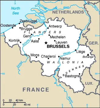
Belgium borders the North Sea, France, and the Netherlands in Western Europe. It is about the size of Maryland, covering a total area of 30,528 sq km. Belgium is known for its temperate climate, flat coastal plains in the northwest, central rolling hills, and rugged mountains of Ardennes Forest in the southeast. Its diverse geography is accompanied by an equally diverse population, including Belgians, Italians, Moroccans, and French.
Belgium Google Maps
Google Maps is an invaluable tool for exploring Belgium’s varied landscape, from the historic streets of Brussels to the scenic Ardennes Forest. It provides detailed and interactive maps essential for navigation and discovering new destinations within the country.
Belgium lies in northwestern Europe. Its history has been marked by tensions between the majority Dutch-speaking (Flemish) and minority French-speaking (Walloon) communities. Low-lying coastal plain covers two-thirds of the country. Land becomes hilly and forested in the southeast (Ardennes).
The map below shows Belgium’s cities, towns, highways, main roads, streets, and Street Views. To find a location, use the form below, type any city or place, view a simple map, and click the “show map” button.
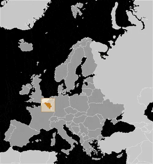
The Google Maps above shows Belgium’s location: Europe (geographic coordinates: 50 50 N, 4 00 E) and the international borders of Belgium; total: 1,297 km. Border countries (total: 4): France 556 km, Germany 133 km, Luxembourg 130 km, Netherlands 478 km; furthermore, it’s inland counties boundaries.
The map of Belgium and Europe is for informational use only. No representation is made or warrantied given any map or content by the Driving Directions and Maps site. The user assumes all risks of using this Belgium Google Maps and facts/wiki.
Climate
Belgium, located in Western Europe, experiences a temperate maritime climate that the North Sea and Atlantic Ocean influence. This climatic condition significantly shapes the country’s agriculture, lifestyle, and cultural practices.
Mild Winters: In Belgium, winters are generally mild, with temperatures rarely falling much below freezing. The average winter temperature ranges from 3°C to 6°C (37°F to 43°F). Snowfall is relatively uncommon, and when it does occur, it doesn’t typically last long. Coastal areas tend to have slightly milder winters compared to the inland regions.
Cool Summers: Summers in Belgium are cool and pleasant, with average temperatures ranging from 13°C to 22°C (55°F to 72°F). Heatwaves are rare, but temperatures can occasionally reach up to 30°C (86°F) or more, particularly in the latter part of the summer.
Rainfall and Humidity: Rainfall is distributed fairly evenly throughout the year, with a tendency for slightly higher rainfall during the summer months. The country averages around 200 days of rainfall annually, contributing to its reputation for having a rainy, humid, and cloudy atmosphere. The average annual precipitation ranges from 65 to 100 cm (25 to 39 inches), varying across different country regions.
Influence on Agriculture: Belgium’s climate, with its sufficient rainfall and mild temperatures, is highly conducive to agriculture. The country produces various crops, including potatoes, sugar beets, wheat, and barley. The moderate climate also supports the cultivation of famous Belgian hops, an essential ingredient in the country’s renowned beer brewing industry.
Impact on Lifestyle and Culture: The temperate climate of Belgium has influenced the country’s lifestyle and cultural practices. The weather often dictates social activities and outdoor events. For instance, the cooler and rainy weather has contributed to developing a vibrant café culture, with people enjoying time indoors. Similarly, the country’s climate has shaped its architectural styles, with buildings often designed to cope with the frequent rainfall and varying temperatures.
Seasonal Variations: Belgium’s climate also brings distinct seasonal changes, with colorful autumns and springs celebrated in various cultural events and festivals. The changing seasons add to the country’s scenic beauty, from blooming flowers in spring to vibrant autumn leaves.
In summary, Belgium’s temperate maritime climate, characterized by mild winters, cool summers, and regular rainfall, significantly influences its agricultural practices, lifestyle, and cultural traditions. The weather patterns create a unique living environment integral to the Belgian way of life.
Geography
Belgium, a Western European country, presents a diverse geographical landscape ranging from flat coastal plains to rugged mountainous regions. This variety in terrain plays a crucial role in the nation’s climate, ecology, and human activities.
Varied Topographical Features:
- Coastal Plains: In the northwest, Belgium features flat coastal plains that extend along the North Sea. This area is characterized by wide, sandy beaches and polders, areas of low-lying land reclaimed from the sea and protected by dikes.
- Central Rolling Hills: Moving inland, the topography transitions to rolling hills in the central part of the country. This region includes fertile valleys and plateaus, vital for agriculture and densely populated.
- Ardennes Forest and Rugged Terrain: The southeast of Belgium is dominated by the Ardennes, a densely forested, hilly, and mountainous region. It extends into neighboring countries and is known for its natural beauty, wildlife, and outdoor recreation opportunities. The highest point in Belgium, Botrange, is located in this region, standing at 694 meters (2,277 feet).
Geographical Size and Boundaries:
- Belgium covers an area of approximately 30,689 square kilometers (11,849 square miles), making it relatively small compared to its European neighbors.
- The country is bordered by the Netherlands to the north, Germany to the east, Luxembourg to the southeast, France to the south and southwest, and the North Sea to the northwest.
Proximity to Major European Cities:
- Belgium’s central location in Europe is close to several major European cities. Brussels, the capital city, is just a short train ride away from cities like Paris, London, and Amsterdam, making Belgium a key player in European commerce and politics.
Water Bodies and Rivers:
- Major rivers in Belgium include the Scheldt and the Meuse, which have historically been crucial for trade and transportation. The extensive network of canals and rivers in Belgium is also significant for commercial shipping and recreational activities.
- Belgium’s coastline along the North Sea is approximately 66 kilometers (41 miles) long, playing an essential role in the country’s maritime activities and tourism.
Environmental Challenges:
- Belgium faces environmental challenges related to its geography, including flooding in low-lying coastal areas and river valleys and forest management in the Ardennes region.
- Urbanization and industrial activities have also challenged the country’s natural landscapes and ecosystems.
Influence on Culture and Economy:
- The geographical diversity of Belgium has influenced its cultural heritage, with different regions having unique customs and traditions.
- Agriculture remains significant in the central rolling hills, while the Ardennes region is known for its natural resources and tourism.
In summary, Belgium’s geography, characterized by its flat coastal plains, rolling hills, and rugged mountains, not only defines its natural beauty and resources but also influences its climate, culture, and economy. The country’s strategic location in Europe further enhances its political and economic connectivity significance.
Resources and Land Use
Belgium’s natural resources include construction materials, silica sand, carbonates, and arable land. Approximately 44.1% of the land is used for agriculture, and the country has a significant forest cover of 22.4%.
Population Data
As of 2023, Belgium has an estimated population of 11,913,633, with a high population density and about 97% of its people living in urban areas. The country is considered one of the most densely populated in the world.
Economic Data
Belgium’s economy is marked by a mix of agricultural, industrial, and service sectors. The country is known for its engineering and metal products, motor vehicle assembly, scientific instruments, processed food and beverages, chemicals, and pharmaceuticals. It has a high-income economy with moderate growth and a strong welfare system.
Drinking Water Source
Belgium boasts 100% access to improved drinking water sources for its urban and rural populations, highlighting its commitment to public health and infrastructure.
Population, Median Age, Migration, and Citizenship
The median age in Belgium is approximately 41.9 years, with a net migration rate of 4.2 migrants/1,000 population. Belgian citizenship is primarily based on descent, and the country recognizes dual citizenship.
Average Number of Childbirths
The average number of childbirths per woman in Belgium is 1.77, indicative of a demographic trend similar to other European countries, where the birth rate is relatively low.
Is this country a Safe Destination?
Belgium is generally considered a safe destination for travelers. However, like any country, visitors should stay informed about local conditions and avoid areas of unrest or demonstrations.
Healthcare and Infectious Diseases
The Belgian healthcare system provides various services, though challenges remain regarding resources. The country has an advanced medical infrastructure, and routine vaccinations are recommended for travelers.
Natural Hazards
Belgium’s primary natural hazard is flooding, particularly along rivers and in reclaimed coastal areas protected by concrete dikes.
The Flag and Other Symbols
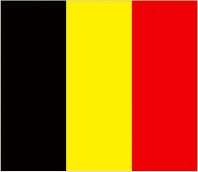
The national flag of Belgium consists of three equal vertical bands: black, yellow, and red. The golden rampant lion is a significant national symbol, representing strength and courage.
Constitution
Belgium’s constitution, first adopted in 1831 and revised in 1993, established a federal parliamentary democracy under a constitutional monarchy. The country has undergone several constitutional amendments to adapt to its evolving political landscape.
Legal System
The Belgian legal system is based on the French Civil Code and has been modified to align with the legislative norms of the European Union. The country has a comprehensive judicial review process of legislative acts.
About the Unemployment Rate, Labor Force, and Poverty Line
Belgium’s unemployment rate stands at approximately 6.42% as of 2021. While the poverty rate is relatively low, economic challenges and inequality persist in certain areas.
About the Budget and Central Government Debt
Belgium’s budget reflects a balance between its revenues and expenditures, with public debt at around 119.43% of GDP in 2020. Managing this debt is crucial for maintaining economic stability.
Inflation Rate and Prime Lending Rate
The inflation rate in Belgium was about 2.44% in 2021. The prime lending rate is a key economic indicator, affecting the cost of borrowing and overall economic health.
Export/Import Partners and Data
Major export partners include Germany, France, and the Netherlands. Belgium’s primary imports consist of cars, refined petroleum, and packaged medicines, with significant trade relations with countries like the Netherlands, Germany, and France.
Renewable Energies Used
Belgium is progressively incorporating renewable energy sources into its energy mix, focusing on solar, wind, and biomass energy. The country is actively working towards reducing its reliance on fossil fuels.
Telecommunication Data, Calling Code
Belgium has a robust telecommunications infrastructure with a high rate of mobile phone usage and internet penetration. The country code for Belgium is +32.
Transport Infrastructure
Belgium boasts an extensive transport network, including roads, railways, and waterways. The country’s well-developed infrastructure facilitates both domestic and international trade and travel.
More Interesting Facts
Belgium, a small yet fascinating Western European country, is often celebrated for its chocolates and beer. However, there’s much more to this nation than these delightful indulgences. Here are some intriguing “Did you know” facts about Belgium that might surprise you:
Did you know?
- The Smurfs and Comic Books: Did you know Belgium has a rich history in comic book creation? It’s the birthplace of the famous blue characters, The Smurfs, created by Peyo (Pierre Culliford). Additionally, the adventures of Tintin, the intrepid reporter created by Hergé, also originated here. Brussels even has a Comic Book Route, where walls throughout the city are dedicated to famous Belgian comic book characters.
- A World Leader in Chocolate: Belgium is renowned for its high-quality chocolate. With over 2,000 chocolatiers and a production of over 600,000 tons of chocolate annually, this country takes its sweet treats seriously. Belgian chocolate became widely known thanks to Jean Neuhaus II, who invented the praline in Brussels in 1912.
- A Country with Three Official Languages: Belgium is unique in its linguistic diversity. It has three official languages: Dutch, spoken by the majority (about 60%) in the Flanders region; French, spoken by around 40% in the Wallonia region; and a small German-speaking community accounting for less than 1%.
- World Record for Longest Time without a Government: After the 2010 federal elections, Belgium set a world record for the longest time without a government. It went for 589 days from 2010 to 2011 without an elected government, a record that the Guinness Book of World Records noted.
- Home to the European Union and NATO: Brussels, the capital of Belgium, is often referred to as the de facto capital of the European Union. It hosts the official seats of the European Commission, the Council of the European Union, and the European Council, as well as a seat of the European Parliament. Brussels is also home to NATO’s (North Atlantic Treaty Organization) headquarters.
- The invention of the Saxophone: Did you know that the saxophone was invented by a Belgian? Adolphe Sax, born in Belgium in 1814, invented this iconic musical instrument in the early 1840s.
- A Pioneer in Railway in Continental Europe: Belgium pioneered railway development in continental Europe. It opened its first railway line in 1835, which ran from Brussels to Mechelen, making it the first country in Europe and the second in the world (after the UK) to have a railway.
- Diamond Capital of the World: Antwerp, a city in Belgium, is known as the “diamond capital of the world.” About 84% of the world’s rough diamonds pass through this city.
- A Country of Castles: Belgium is known for having one of the highest densities of castles in the world. It’s estimated that there are over 3,000 castles in the country, ranging from medieval fortresses to luxurious chateaus.
These facts showcase Belgium’s rich cultural and historical heritage and its significant role in global affairs and innovations. Whether it’s through its contribution to the arts, gastronomy, or international politics, Belgium continues to be an intriguing and important country on the world stage.
Many thanks for visiting and sharing this map & country information site!


