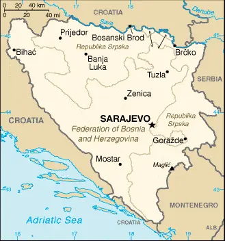
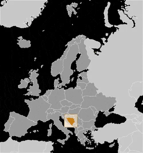
Google Maps and Detailed Facts of Bosnia and Herzegovina (BA). This page lets you explore Bosnia and Herzegovina and its border countries (Country Location: Southeastern Europe, bordering the Adriatic Sea and Croatia) through detailed Satellite imagery – fast and easy as never before Google Maps.
Find comprehensive information about this country’s diversity below: Google Maps, geography, economy, science, people, culture, environment, government, and history – All in One Wiki page.
There is also a Street View and free Driving Directions at your service. Your Google Satellite Map Sightseeing in Bosnia and Herzegovina, in Europe, starts here at Driving Directions and Maps.com.
About Bosnia and Herzegovina in detail
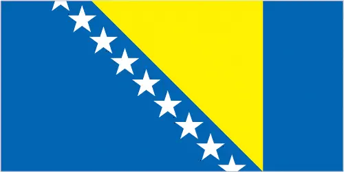
| Borderline map of Bosnia and Herzegovina | Location map of Bosnia and Herzegovina | Flag of Bosnia and Herzegovina |
|---|---|---|
 |  |  |
Table of contents
- Background
- Overview
- Google Maps
- Climate
- Geography
- Resources and Land Use
- Population Data
- Economic Data
- Drinking Water Source
- Population, Median Age, Migration, and Citizenship
- Average Number of Childbirths
- Is this country a Safe Destination?
- Healthcare and Infectious Diseases
- Natural Hazards
- The Flag and Other Symbols
- Constitution
- Legal System
- About the Unemployment Rate, Labor Force, and Poverty Line
- About the Budget and Central Government Debt
- Inflation Rate and Prime Lending Rate
- Export/Import Partners and Data
- Renewable Energies Used
- Telecommunication Data, Calling Code
- Transport Infrastructure
- More Interesting Facts
Background
Bosnia and Herzegovina declared sovereignty in October 1991 and independence from the former Yugoslavia on March 3, 1992. This period was marked by armed resistance from ethnic Serbs, supported by neighboring Serbia and Montenegro. The conflict aimed to partition the country along ethnic lines, leading to years of civil strife. A significant turn occurred in March 1994 when Bosniaks and Croats formed a joint federation. The Dayton Peace Accords in November 1995 ended the conflict, retaining the country’s international boundaries and establishing a multiethnic and democratic government. This government, along with the Republika Srpska, oversees most government functions under the observation of the Office of the High Representative.
Overview
Bosnia and Herzegovina, located in Southeastern Europe, bordering Croatia and the Adriatic Sea, is slightly smaller than West Virginia. The country is known for its diverse ethnic composition and complex political structure resulting from the Dayton Accords. It comprises two main entities: the Federation of Bosnia and Herzegovina and the Republika Srpska. The capital, Sarajevo, is noted for its historical significance and cultural heritage.
Official Name: Bosnia and Herzegovina
Date of Formation: Independence was declared on 3 March 1992
Capital: Sarajevo
Population: 3,807,764 (2023 estimate)
Total Area: 19,767 Sq. Miles / 51,197 Sq. Km
Population Density: N/A
Languages: Bosnian (official) 52.9%, Serbian (official) 30.8%, Croatian (official) 14.6%, other 1.6%, no answer 0.2% (2013 est.)
Religions: Muslim 50.7%, Orthodox 30.7%, Roman Catholic 15.2%, atheist 0.8%, agnostic 0.3%, other 1.2%, undeclared/no answer 1.1% (2013 est.)
Ethnic Origin: Bosniak 50.1%, Serb 30.8%, Croat 15.4%, other 2.7%, not declared/no answer 1% (2013 estimate)
Government: Parliamentary republic
Currency: Convertible Marka (BAM)
Literacy Rate Rate: Total population: 98.1%, Male: 99.4%, Female: 98.1% (2021)
Calorie Consumption: N/A
Bosnia and Herzegovina Google Maps
Google Maps provides comprehensive views and navigational assistance across Bosnia and Herzegovina. From Sarajevo’s urban landscapes to the Dinaric Alps’s rugged terrains, it’s a valuable tool for residents and visitors exploring the country’s diverse regions.
Perched in the highlands of southeast Europe, Bosnia and Herzegovina focused on the bitter ethnic conflict that accompanied the early 1990s dissolution of the Yugoslav state. Hills and mountains, with narrow river valleys. Lowlands in the north. Deciduous forest covers about half of the total area.
The map below shows Bosnia and Herzegovina’s cities, towns, highways, main roads, streets, and Street Views. To find a location, use the form below, type any city or place, view a simple map, and click the “show map” button.
The Google Maps above shows Bosnia and Herzegovina’s location: Europe (geographic coordinates: 44 00 N, 18 00 E) and Bosnia and Herzegovina; total: 1,543 km. Border countries (total: 3): Croatia 956 km, Montenegro 242 km, Serbia 345 km; furthermore, it’s inland counties boundaries.
The map of Bosnia and Herzegovina, Europe, is for informational use only. No representation is made or warrantied given any map or content by the Driving Directions and Maps site. The user assumes all risks of using this Bosnia and Herzegovina Google Maps and facts/wiki.
Climate
Due to its varied topography, Bosnia and Herzegovina’s climate exhibits significant regional variations. The country’s climatic diversity is shaped by its geographical position in Southeast Europe and its topographical mix of high mountains, rolling hills, and narrow coastal areas.
- Continental and Mediterranean Influences: The interior of Bosnia and Herzegovina experiences a continental climate characterized by hot summers and cold, snowy winters. The coastal area, however, enjoys a Mediterranean climate, with mild, rainy winters and hot, dry summers. This contrast results from the country’s positioning between the Dinaric Alps and the Adriatic Sea.
- Mountainous Regions: The climate is alpine in the high-elevation areas, particularly in the Dinaric Alps. These regions experience short, cool summers and long, severe winters with heavy snowfall. The snow cover in winter can last for several months, making these areas popular for winter sports.
- Precipitation Patterns: Bosnia and Herzegovina has relatively high precipitation levels, with the northwest receiving the most rain. This is due to the orographic effect where moist air masses from the Adriatic Sea ascend along the mountain slopes, cooling and releasing precipitation. This makes the country one of the wettest in Europe, particularly in the higher elevations.
- Temperature Variations: Average temperatures vary significantly across the country. Coastal areas have mild temperatures, averaging around 8°C in winter and 25°C in summer. In contrast, the central and eastern highland areas experience much colder winters, with average temperatures often below freezing and moderately warm summers.
- Microclimates: The complex topography creates numerous microclimates. Narrow valleys can have significantly different weather patterns compared to nearby mountain peaks. For instance, the Neretva Valley and other river valleys are warmer and less snowy in winter than the surrounding mountains.
- Impact on Agriculture and Biodiversity: Climatic diversity supports various agricultural activities and a rich biodiversity. The Mediterranean climate along the coast is favorable for olives, citrus fruits, and grapes, while the continental regions are suited for grains, potatoes, and livestock farming. The varied climates also contribute to the country’s rich biodiversity, including diverse forest types and various animal species.
Understanding Bosnia and Herzegovina’s climate is crucial for various sectors, including agriculture, tourism, and environmental management. The country’s distinct seasonal changes and diverse microclimates pose challenges and opportunities for these sectors.
Geography
Expanding upon the geographical data of Bosnia and Herzegovina, this country’s location and terrain play a significant role in its cultural and economic characteristics. The country is nestled in the Balkan Peninsula, surrounded by Croatia to the north, west, and south, Serbia to the east, and Montenegro to the southeast.
- Borders and Land Area: Bosnia and Herzegovina has a total land boundary of approximately 1,543 kilometers. This includes borders with Croatia (932 km), Serbia (345 km), and Montenegro (266 km). The country’s total area of 51,197 square kilometers makes it slightly smaller than countries like Costa Rica or Slovakia.
- Topography and Elevation: The country is predominantly mountainous, featuring the Dinaric Alps. The highest peak is Maglić at 2,386 meters, located on the border with Montenegro. The mountains contribute to Bosnia and Herzegovina’s significant elevation variations, with the lowest point at the Adriatic Sea level.
- River Systems: Major rivers include the Bosna, Vrbas, Sava, and Drina. The Sava River forms the northern natural border with Croatia, while the Drina forms part of the eastern border with Serbia. These rivers are crucial for the country’s hydrology and have been historically significant for trade and transport.
- Land Use and Soil: Approximately 42.2% of the land is arable, with a significant portion covered by forests and woodland. The country’s soil and terrain are conducive to agriculture in the valleys, where conditions are less rugged.
- Climate Influence on Geography: The varied climate, ranging from the Mediterranean along the narrow coastal strip to continental in the interior, influences the geographical distribution of vegetation and land use. Dense forests and pastures characterize mountainous areas, while the more temperate regions support agricultural activities.
- Natural Resources: Bosnia and Herzegovina has natural resources, including iron ore, bauxite, copper, lead, zinc, coal, timber, and hydropower potential. These resources have significant implications for the country’s economy and industries.
- Environmental Concerns: Challenges include deforestation, air and water pollution from industrial activities, and hazardous waste disposal. While a strength in many respects, the country’s geographical diversity also presents unique environmental management challenges.
- Urban Centers and Population Distribution: The capital and largest city, Sarajevo, is situated in a valley and is a prime example of the country’s typical terrain influencing urban development. Other major cities like Banja Luka, Mostar, and Tuzla are also located in valleys or near river basins, following the trend of population centers developing in more geographically hospitable areas.
The geography of Bosnia and Herzegovina, shaped by its mountainous terrain, river systems, and varied climate, has played a pivotal role in its historical, cultural, and economic development. The interaction with neighboring countries also adds to the geopolitical significance of its geographical position.
Resources and Land Use
The country has notable natural resources, including coal, iron ore, bauxite, copper, lead, zinc, and timber. About 42.2% of the land is used for agriculture, while forests cover 42.8% of the country.
Population Data
As of 2023, the estimated population of Bosnia and Herzegovina is 3,807,764. The most densely populated areas are in the northern and central regions.
Economic Data
The economy of Bosnia and Herzegovina is import-dominated and consumption-heavy. It faces challenges such as high unemployment and a need for more private-sector investments and diversification. The GDP in 2021 was estimated at $51.244 billion.
Drinking Water Source
Regarding water sources, 99.9% of the urban and 100% of the rural populations have access to improved water sources.
Population, Median Age, Migration, and Citizenship
The median age in Bosnia and Herzegovina is 44.4 years as of 2023. The country has experienced a negative population growth rate and a net migration rate of -0.4 migrants/1,000 population.
Average Number of Childbirths
The total fertility rate in Bosnia and Herzegovina is 1.37 children born/woman as of 2023.
Is this country a Safe Destination?
While Bosnia and Herzegovina is generally safe for tourists, visitors should be aware of the remnants of landmines in some rural areas from past conflicts.
Healthcare and Infectious Diseases
The country has a reasonable healthcare system with a physician density of 2.16 physicians/1,000 population. It allocates 9.8% of its GDP to healthcare.
Natural Hazards
Bosnia and Herzegovina are prone to destructive earthquakes due to their geographic location.
The Flag and Other Symbols
The flag features a blue vertical band with a yellow triangle and white stars, symbolizing neutrality, peace, and its constituent peoples. The national symbols include the golden lily and the colors blue, yellow, and white.
Constitution
The country’s constitution, part of the Dayton Peace Accords, was adopted on 14 December 1995. It has undergone several amendments, the last being in 2009.
Legal System
Bosnia and Herzegovina operates under a civil law system with a Constitutional Court that reviews legislative acts.
About the Unemployment Rate, Labor Force, and Poverty Line
The unemployment rate in 2021 was estimated at 15.22%. The country also faces challenges with poverty, with 16.9% of its population below the poverty line as of 2015.
About the Budget and Central Government Debt
The public debt of Bosnia and Herzegovina was 46.05% of its GDP in 2020. Government revenues in 2019 were estimated at $8.434 billion.
Inflation Rate and Prime Lending Rate
The inflation rate in 2021 was estimated at 1.98%. The country uses the Konvertibilna marka (BAM) as its currency.
Export/Import Partners and Data
Major export partners include Germany, Italy, and Croatia, focusing on electricity, seating, and insulated wiring. Imports, including refined petroleum and cars, mainly come from Croatia, Serbia, and Germany.
Renewable Energies Used
In terms of energy, hydroelectricity accounts for 35.4% of the total installed capacity, with a significant portion also coming from fossil fuels.
Telecommunication Data, Calling Code
The telecommunication sector is liberalized, with growing broadband connectivity and mobile services. The country code is +387.
Transport Infrastructure
The country has a developing transport infrastructure, including roads, railways, airports, and river ports.
More Interesting Facts
Bosnia and Herzegovina are known for their rich history, cultural diversity, and natural beauty, including the UNESCO World Heritage Site of Mostar’s Old Bridge. The country aspires to join NATO and the EU, reflecting its ongoing political and economic integration efforts.
Did you know?
- Sarajevo’s Unique History: Sarajevo, the capital city, hosted the 1984 Winter Olympics. It’s one of the only cities in the world that, within a century, went from hosting a global sporting event to being under siege during the Bosnian War in the 1990s. The Sarajevo Tunnel, built during the siege to supply the city, is now a significant historical site.
- Stari Most – An Architectural Marvel: The iconic Stari Most (Old Bridge) in Mostar, originally built in the 16th century, is a testament to Ottoman engineering. It was destroyed in 1993 during the Bosnian War but meticulously rebuilt and reopened in 2004. The bridge and its surroundings are UNESCO World Heritage Sites.
- A Country of Diverse Religions: Bosnia and Herzegovina are known for their religious diversity, with significant Muslim, Orthodox Christian, and Catholic populations. This coexistence is symbolized in Sarajevo, where a mosque, a Catholic cathedral, an Orthodox church, and a synagogue can be found within walking distance.
- Unique Ecosystems: The country has one of Europe’s last remaining ancient forests, Perućica, located in the Sutjeska National Park. Some of the trees in Perućica are over 300 years old, and the forest is home to a wide range of flora and fauna, some of which are endemic.
- Stećci – Medieval Tombstones: Bosnia, Herzegovina, and some neighboring countries are home to a unique collection of medieval tombstones known as Stećci. UNESCO recognizes these for their historical and artistic value. There are more than 60,000 of these tombstones across the country.
- A Linguistic Melting Pot: The Bosnian language, similar to Serbian and Croatian, exhibits influences from Turkish, Arabic, and Persian due to the country’s history under Ottoman rule. This linguistic blend is evident in everyday speech and local culture.
- Rich Coffee Culture: The traditional Bosnian coffee, similar to Turkish coffee, is integral to the country’s culture and social life. Preparing and enjoying coffee is a cherished ritual, reflecting the country’s Ottoman heritage.
- Land of Rivers and Waterfalls: Bosnia and Herzegovina are known for their abundant rivers, waterfalls, and clean water sources. The Kravice Waterfalls on the Trebižat River are a stunning natural wonder, often compared to miniature versions of Niagara Falls.
- A Hidden Gem for Filmmakers: The country’s diverse landscapes and historical settings have made it a favored location for filmmakers. It has served as a backdrop for various international film productions, offering settings that range from ancient to contemporary.
These intriguing facts highlight Bosnia and Herzegovina’s rich history, diverse culture, and unique natural beauty, making it a fascinating country with much to offer.
Many thanks for visiting and sharing this map & country information site!
